Surrounded at Noville
20/12/44
V3.0 - map again updated
Pics from the game (V1.0)
This scenario is based upon work done by Dave Norman
During the Battle of the Bulge 2 Panzer Division was tasked with seizing the bridges over the Meuse. However the road network was so constricted in the Ardennes they found themselves entangled with the US troops defending Bastogne. On the main road into Bastogne is the hamlet of Noville. On the 18th this was garrisoned by Team Desobry from the 10th Armored Division, with orders to hold at al costs. On the 18th and early on the 19th there were confused skirmishes in the fog between the Americans and the Germans. Major Desobry was on the verge of pulling out his battered troops when reinforcements arrived: 1st Battalion 506th Parachute Infantry Regiment. The Paras instantly went on the offensive and attacked up the ridge that was held by the Germans north of the village. They ran smack into a German armoured attack on the slopes of the hill. The Para's attack failed but so did the Germans and both side slunk back to their start lines.
There was a noisy night in store for the Para's and Major Desobry's troops, the Germans constantly shelled the village in anticipation of a final attack on the Morning of the 20th
In the meantime on the Americans' right flank their comrades had been forced back, and German grenadiers had moved into the woods to the east. The defenders in Noville were soon to be surrounded and cut-off from retreating to Bastogne.
The scenario depicts 2 Panzer Division's assault on Noville and 26 Volks Grenadier Division's attempt to take the road to Bastogne, a confused, desperate battle in the fog
[Note this battle is balanced ONLY if the US Paras are rated ROF1, not the official ROF2/3]
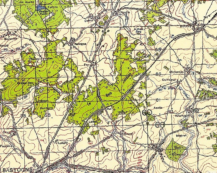
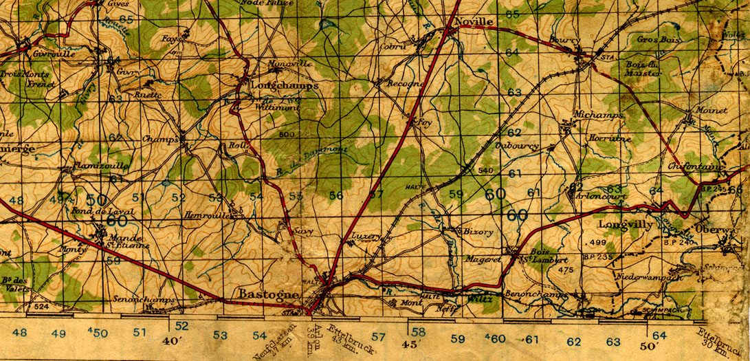
WW2 Map of the area north of Bastogne (from: http://geo.nls.uk/maps/index.html )
Map and Order of Battle
Deployment
US Forces are deployed in the zones delineated by the thin pink dashed lines. US Personnel stands are in foxholes (not towed gun stands). US halftracks may not start in the BUA's, neither may they enter in turn 1
German forces, excepting I/304 PzGr and II/78 VGR, are deployed in the zones delineated by the thin pink dashed lines.
I/304 PzGr enters the board turn 1 between A & B
II/78 VGR is a reinforcement arriving turn 10 it arrives within 6" of either point C or D
Terrain
The open ground is very open. Fields with no cover at their boundaries. However there are small stands of trees dotted around and the open ground undulates more than the ridgelines suggests. LOS should be limited to 24" unless either the observer or target is touching a ridgeline when LOS extends to 36"
Red lines are roads main roads, pink lines are minor roads. Where the roads have tree lines adjacent all stands on the road are assumed adjacent to the tree line.
The blue lines are ditches. Personnel and tracked vehicles are not impeded in crossing. Manhandled guns and wheeled vehicles cost a BMA. personal stands (but not towed guns) in the ditch get -2 cover from shooting from outside the river
Brown dotted lines are ridgelines. They break LOS and give AFV's the benefit of hull down (-2)
The green areas are forest, impenetrable to vehicles and man-handled guns, 1/2 speed for personnel stands. Light cover (-1). All roads, trails and railways through the woods: visibility along them is max 6" and all stands on them count as light cover (-1)
The black dotted line is a railway, the green dotted lines are trails through the woods. In game terms they are both treated the same. They count as open ground for movement purposes, however they are eligible for personnel stands to travel march down.
The green dotted lines are tree lines. The tree lines break LOS and give -1 cover
The large grey squares are 4x4 stone BUA's, the smaller 2x2 BUA's (-3 cover). The smaller BUA's can hold 1 personnel or Class I gun stand only. In the 4x4 BUA's The actual buildings are well spread out so may be entered by vehicles which may fire normally. However Vehicles only get -1 cover within
I have taken some pictures of the modern day battlefield to aid in getting a "feel" for the terrain. The red numbers and arrows on the map correspond to the pictures

Noville in 1944 - from (http://www.history.army.mil/books/wwii/7-8/notes/41A.jpg)
Special Rules
Game starts at 0800 and last 14 Turns
The weather is foggy. The fog came and went during the day. At the start of each turn (i.e. after orders are laid) roll 1d10 to determine the visibility for the turn
1-5 Foggy: 2 Visibility
6-7 Misty: 20 Visibility
8-11 Max Visibility
+1 to dice from Turn 8
Victory Conditions
There are three victory locations: Noville (4x4 BUA only), Foy and Point E or Point F. E or F counts as one victory location the Germans have to hold one or the other they do not have to hold both..
For a standard victory the Germans must hold two victory locations at the end of the last turn. For a decisive victory the Germans must hold all three locations. The US gains a standard victory if the Germans hold only one location, a decisive victory if the fail to hold any locations
Noville only counts as taken at the end of the game if it was taken at the end of turn 10 by the Germans (if its taken at the end of turn 10, then lost and re-taken that's good enough) i.e. Noville must be captured by the end of turn 10 to count.
To hold the Point E or Point F the Germans must be the only side with stands in good morale within 3" of the point. If they are not the points are contested.
To hold a BUA the Germans must have at least one personnel stand in good morale in the BUA, while the enemy must not have any personnel stands in good morale in the BUA(s). Stands must be wholly in the BUA to count
Good morale is not shaken and not demoralised.
References
Time for Trumpets - Charles MacDonald
Fire Brigades - Kamen Neverkin - 2 Panzer Division strength and organisation
http://forum.axishistory.com/viewtopic.php?t=84874 - covers issue of Assault Rifles to 26VGD
http://www.506infantry.org/hiswwiimap02.html - outline of the day's fighting from 506th's war diary
http://www.101airborneww2.com/BastMap.jpg - 1944 1:100000 map of the area
http://history.sandiego.edu/cdr2/BYRD/BATTLE_O/GREEN_BO/CHAP_14.TXT - Official Army History
http://www.feldgrau.net/forum/viewtopic.php?f=24&t=12316&hilit=noville - chronology of events including s few details on German dispositions